I frequently get questions about groundwater and why water is in the ground – AND – more specifically, how to find water in the ground.
Groundwater comes from rain that gets into the soil and then flows downhill underground. When we drill a well, it is this groundwater that we are tapping into. I can not explain it nearly as well as the Water Encyclopedia does.
The following information is excerpted from an article at the Water Encyclopedia site:
Groundwater is water that occurs below the Earth’s surface at depths where all the pore (open) spaces in the soil, sediment , or rock are completely filled with water (see Figure 1).
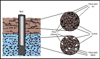
Figure 1. In the unsaturated zone, pore spaces contain air; hence, no groundwater can be pumped from this zone. Usable groundwater occurs in the saturated zone, where pore spaces are completely filled with water.
FROM THE WATER ENCYCLOPEDIA
A shallow well or a deep well , originates and is replenished (recharged) by precipitation.
Groundwater is part of the hydrologic cycle, originating when part of the precipitation that falls on the Earth’s surface sinks (infiltrates) through the soil and percolates (seeps) downward to become groundwater. Groundwater will eventually come back to the surface, discharging to streams, springs, lakes, or the oceans, to complete the hydro-logic cycle.
Groundwater Zones:
A well that is drilled will first pass through a zone called the unsaturated (vadose) zone where the openings in the soil, sediment, or rock are primarily filled with air (Figure 1). Water exists here only in transit downward. The thickness of this zone depends on such factors as climate, elevation, season of the year, and area-wide groundwater withdrawals through pumping. In the rainy season of humid areas, the unsaturated zone may be a fairly thin layer, extending from the land surface to only a few meters (10 feet or so) below the surface. But in drier months of the year, the unsaturated zone may extend deeper as recharge to the aquifer declines and withdrawals increase. In arid regions, the unsaturated zone may be a thick layer, extending from the land surface to 300 meters (1,000 feet) or more below it.
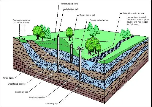
Further drilling will reach a zone called the saturated zone where all of the openings are filled with water, and where the water is known as groundwater. If the saturated zone is permeable enough to supply a well with water under normal hydraulic gradients, this saturated zone is called an aquifer. Importantly, an aquifer is not an underground river, lake, or pool. Rather it consists of geologic materials whose open spaces (pore spaces) are filled with water that moves down a pressure gradient, and which can be tapped productively by wells. The top of the saturated zone is called either the water table (if the aquifer is unconfined) or the potentiometric surface (if the aquifer is confined): see Figure 2.
To visualize the zones, imagine a bucket filled with gravel. Ample pore space exists between the individual pieces of gravel. If water is poured on top of the gravel, the water will percolate down through the pore spaces and begin to fill these spaces from the bottom up. The water in pore spaces at the bottom of the bucket represents groundwater; that is, all the pore spaces are filled with water. If holes were punched in the bottom of the bucket, water would flow out. Using this analogy, the bucket of gravel is like an aquifer: water is stored within in it and will move through it toward a discharge point—in this case, the hole in the bucket.Permeability is determined by the size of pores and the degree to which they are interconnected, and hence, the ease by which water can flow through the material. Highly permeable aquifers, such as those comprised primarily of coarse sand and gravel, can supply more water than less permeable aquifers, such as those comprised of silts or clays. In this example, the pores in sand and gravel are larger than those in silt and clay, so water moves through sand and gravel more quickly. In some aquifers, especially in sedimentary bedrock, water occurs in fractures (cracks) instead of pore spaces in sediments. The yield from a fractured rock aquifer can vary from less than 1 liter per minute, or about 0.3 gallons per minute (if the well encounters few fractures) to large quantities of groundwater—for example, more than 300 liters per minute, or about 100 gallons per minute (if the fractures are numerous and large).
FROM THE WATER ENCYCLOPEDIA
AQUIFERS. The water table defines the top of an unconfined aquifer. Water in a well penetrating an unconfined aquifer will remain at the elevation of the water table. Some streams and lakes intercept the water table, allowing direct groundwater–surface water exchange. The potentiometric surface reflects the water pressure of a confined aquifer, and is the level to which water in a well will naturally rise (i.e., to an elevation above the confined aquifer it penetrates). WELLS. All wells in confined aquifers are considered artesian wells. If the elevation of the potentiometric surface is above than the elevation of the land surface, groundwater will flow naturally (without pumping) from the well, known as a flowing artesian well. RECHARGE. Recharge to unconfined aquifers occurs over a wide area of the unsaturated zone, directly above the aquifer. Recharge to confined aquifers occurs only where there is a pathway (e.g., a fracture) through the confining layers, or where the confined aquifer is exposed at the surface and becomes unconfined. Generally, the recharge area for a confined aquifer is at a higher elevation than the aquifer itself, and may be many kilometers from the well.
Aquifer and Well Types.
Aquifers are divided into two types: unconfined and confined. An unconfined aquifer is often shallow, and the vadose zone above it primarily contains permeable material. The top of the aquifer is the water table. The water table moves up and down on a seasonal basis. It is highest during the wet season owing to higher recharge and lower pumping rates (e.g., no irrigation), and lowest during the dry season because of limited recharge and higher use (e.g., a high rate of irrigation).
Confined aquifers may be shallow or deep, and are characterized by being separated from the surface by low-permeability strata (e.g., geologic layers) that confines the groundwater below it. In a confined aquifer, groundwater is generally under pressure. This water pressure may vary seasonally, similar to the water table in an unconfined aquifer.
Because groundwater in a confined aquifer is under pressure, it will rise in a well bore above the level of the aquifer penetrated by that well. One way to visualize this is to squeeze a milk or juice pouch that is punctured at the top by a straw. If the straw fits firmly into the squeezed pouch, the liquid will rise up into the straw, above its level inside the pouch.
Artesian and flowing artesian wells are typical of wells drilled into confined aquifers. An artesian well is one in which the groundwater rises above the level of the penetrated aquifer. The water in an artesian well will rise to an elevation at which the pressure of the water in the aquifer is matched by the pressure reflected by the elevation of the water in the well; this level is known as the hydrostatic level. If groundwater reaches all the way to the surface under its own pressure, the well is called a flowing artesian well.
I hope you will take the time to read the whole article at http://www.waterencyclopedia.com/Ge-Hy/Groundwater.html as well as take a look at some of the other information on Water Encyclopedia site. This is an excellent site and very educational. Go to this site and explore. http://www.waterencyclopedia.com/